
As busy and congested as airport surfaces are, having as much situational awareness as possible helps prevent incidents, minimize fuel burn and emissions, decrease turnaround times and optimize usage of ground support equipment (GSE). The Collins Aerospace Airport Surface Awareness System enables airports, airlines and ground crews to track, monitor and record both aircraft and GSE, providing a real-time holistic view of airport operations that delivers a whole new level of airfield surface awareness.
Using three key components – aircraft tracking with ADS-B, GSE asset tracking and an interactive map application with geofencing – the Airport Surface Awareness System is designed to give users both a big-picture and zoomed-in view of operations to deliver actionable insights for quick decision-making. The system is also integrated with FlightAware tracking information, as well as our AirPlan™ Airport Operational Database (AODB) and Resource Management System (RMS), putting even more critical decision-making information right at your fingertips, all in one place.
Aircraft tracking
Unlike other tracking applications, the Airport Surface Awareness System uses ADS-B to track aircraft in the air and monitor them on the ground, giving operators the most situational awareness available and the best chance of avoiding accidents. ADS-B uses GPS coordinates that are uploaded to the system's database, providing positional accuracy to as little as 2 meters or less. Users can capture runway usage, taxi-time and liftoff data to track estimated fuel burn and turnaround times, and incorporate aircraft status information like ACARS, air traffic control (ATC) and airline operational communication (AOC).
- 1,730 runway incursion incidents in
2022 in the United States
- 1,000+ due to pilot deviation
- 300+ due to vehicle deviation
- Globally, 28.6% of fatal accidents caused by runway incursions
- 0 fatalities is the ICAO target for 2030
Asset tracking
The Airport Surface Awareness System uses LoRa® telematics and long-range, wide-area network (LoRaWAN) technology to track vehicles through the system, which can support thousands of assets to provide durable, low-power, long-range connectivity. The technology provides exceptional positional accuracy of less than 2 meters. If required, GPS and differential GPS can be utilized to improve accuracy to just a few centimeters.
Interactive map application and reporting
Using the situational awareness capabilities of geofencing to track the real-time location of all aircraft and GSE on the airfield, the Airport Surface Awareness System makes it easy to monitor everything through its interactive map application. Operators can manage the full asset database, incorporate Notice to Air Mission (NOTAM) notifications, quickly set speed limits based on aircraft and vehicle type rules, create geofences on the fly, monitor for perimeter intrusions and receive alerts, use the playback tool for investigations and generate operational reports.
Airport surface awareness
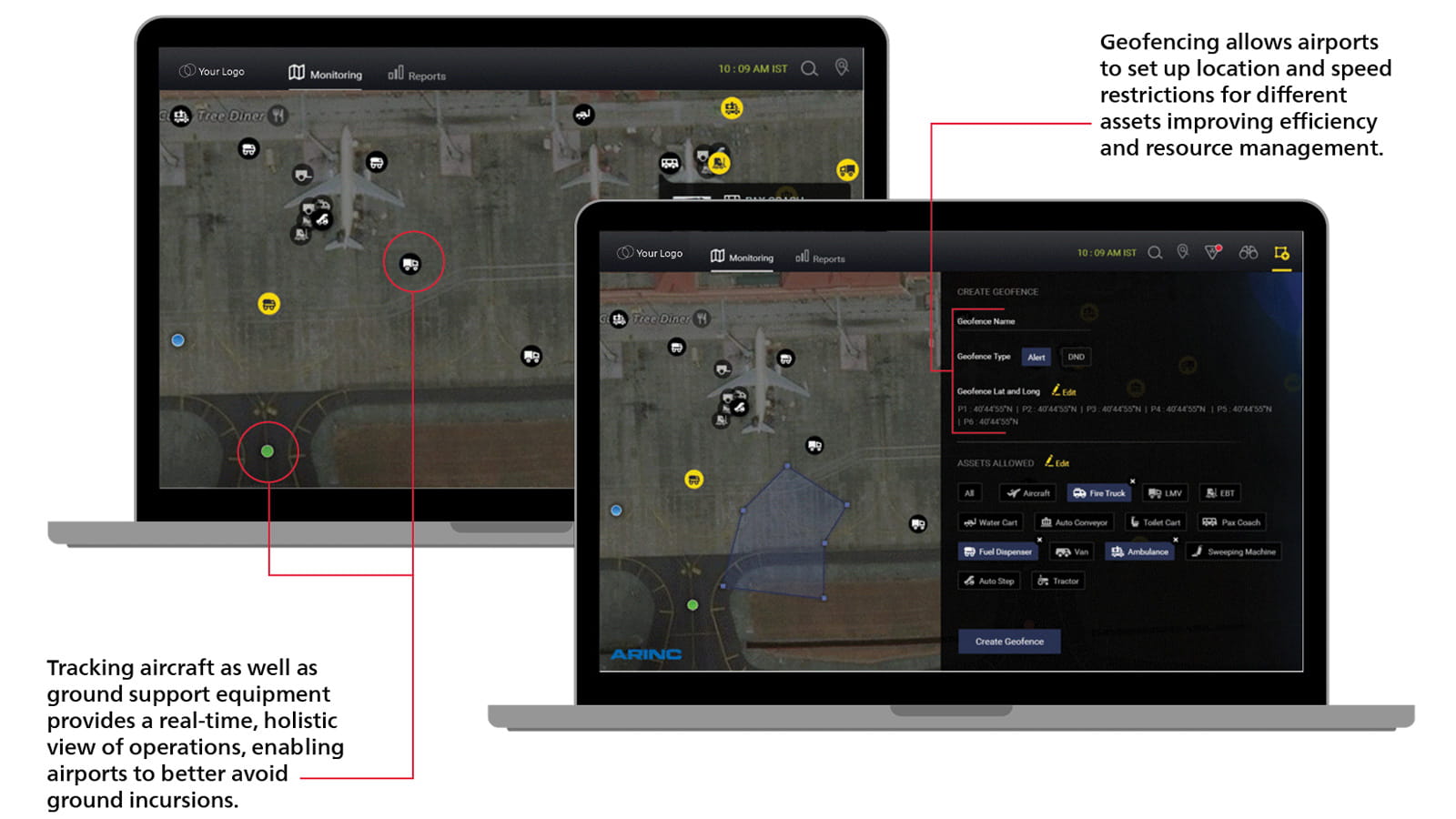
(Left): Tracking aircraft as well as ground support equipment provides a real-time, holistic view of operations, enabling airports to better avoid ground incursions.
(Right): Geofencing allows airports to set up location and speed restrictions for different assets, improving efficiency and resource management.
10 minutes of inefficiency on the airfield can cost up to $488 in excess fuel burn per flight and 1,441 kg of CO2 emissions per aircraft.
FlightAware integration
The Airport Surface Awareness System seamlessly integrates FlightAware's flight tracking technology, giving users access to even more real-time data for holistic airfield management. By incorporating FlightAware's data, including elements such as expected arrival times, operator, route and runway information, and passenger counts, users can more efficiently manage idling, taxiing and GSE allocation to decrease turnaround times.
AirPlan™ integration
Collins' AirPlan™ solution, an all-in-one AODB and RMS, is also fully integrated into the Airport Surface Awareness System, providing airports and airlines a big picture view of all their operations – in the air, on the surface, at the gate and in the terminal. With full visibility of all resources inside and outside of the airport in one place, users will have a single source of truth for planning, operational collaboration and decision-making.
Request information
I would like more information about this capability.